Tools & things made
Rafts and log floats
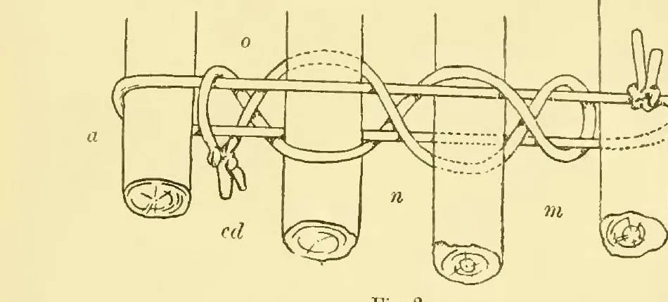
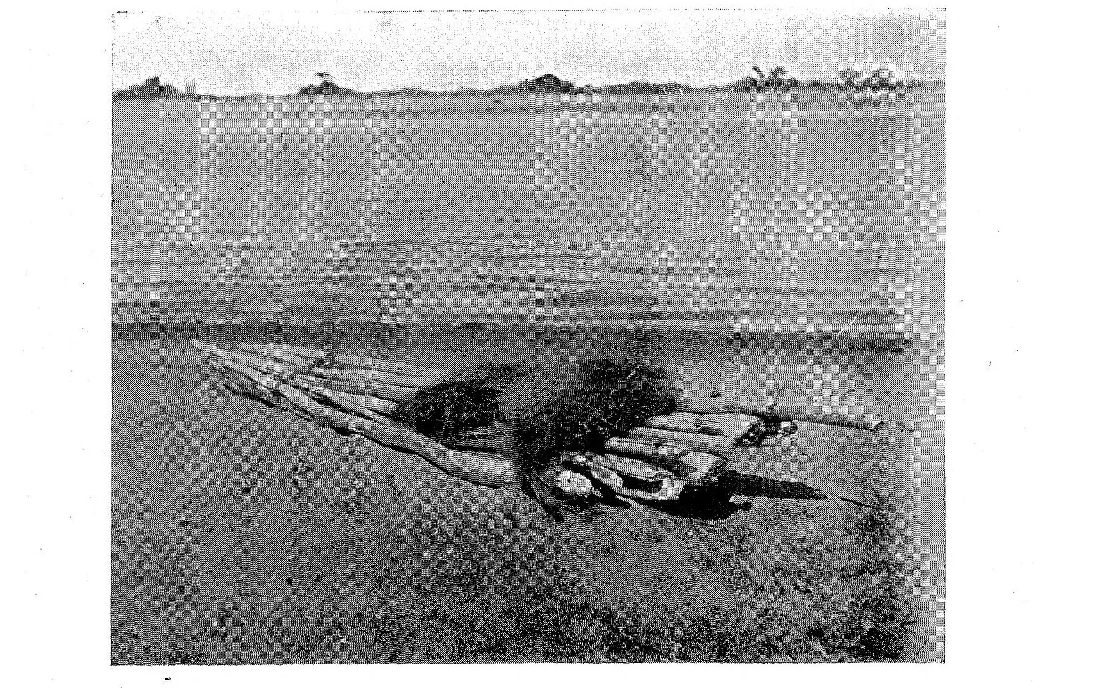
A raft is what a river in flood gets when there is no canoe: 'these log-rafts are used rather in times of flood than at others, and are generally discarded after use'[1]. The dictionary has the parts, walmba 'log' and walngkal 'to float, as a log on the water', and mariji-y 'to swim across or through water', but no word for the raft itself, and Roth records none on Kuku Yalanji country: the log raft he drew was the warra-jan of the lower Tully, 'met with among the scrub-blacks from the Tully to the Russell and Mulgrave Rivers'[2][1]. Four or five light logs, cut off blunt, tied afloat with lawyer cane at the two ends only, a scrap of teatree bark and sand at one end to carry a fire, and a pole to steer and punt with: that is the whole craft, and his figure of the lashing is on this page[1]. Far down the Mitchell, 'at the mouth of the Mitchell River', the crossing tool was a single log of some very light tree, five or six feet long, straddled 'somewhat in the position of a child riding a hobby-horse', one hand to balance and one free for the spears[1].
Hann River Cape York
Possum People's country on the upper river and Thaypan (Kuku Thaypan) country downstream: stringybark and bloodwood woodland and a spring-fed sandy river that runs north-east from the Great Dividing Range, past the Peninsula Developmental Road, into Rinyirru (Lakefield) and the North Kennedy. Not Kuku Yalanji country: the Kuku Yalanji words on this page are the dictionary's, not the Hann's own languages. Place guide
No raft or log float is recorded for the Hann River country. The nearest written records of crossing water are Roth's from the lower Normanby, downstream at Princess Charlotte Bay, where crocodile rivers were crossed by diving[1]. The Hann is a spring-fed river that has not stopped flowing since its gauge opened in 1968: a flood river in the wet, a low clear run between deep holes in the late dry[3][4].
When the Hann has to be crossed
Wet, December to March. 'During the peak of the wet season (December to March), heavy rains cause the rivers to flood'[5]. At the Sandy Creek gauge the Hann runs highest in February and March, a mean of about 20–22 m³/s; the biggest daily mean on record was about 430 m³/s, on 12 February 1974[3]. Rinyirru's roads close in the wet, 'usually December to May'[6].
Dry. By September to November the river is down to about 0.3–0.4 m³/s[3]. It is then a low, clear run between deep holes, fed by springs, never dry sand[4].
How people crossed water here
Lower Normanby (Princess Charlotte Bay), Roth, about 1900. Where 'a known crocodile-infested river has to be crossed, and there is no canoe, the black manages it by diving', close to the bottom, stirring up the mud if a crocodile comes. Lily-seed divers had a friend watching from the bank[1]. Roth adds, without naming a district, that 'a river in flood is met by diving across close to the bottom, where the natives say the current is never so strong'[1].
Kuku Thaypan. Elder Dr George Musgrave told of the messmate, Ku Aldkalemba: you take its bark 'only get certain time after wet' to make a humpy, and 'you can make canoe out of him'; it also made a dish, Karoll[7]. See canoes. No Kuku Thaypan raft is described.
Safety here
Both crocodiles live in this river system; treat every deep hole on the Hann as saltwater crocodile water. See crocodiles for the Hann River in full.
On country today
The upper Hann is the Possum People's country[8]; the middle and lower Hann are in the Thaypan native title determination of November 2023, held by the Awu-Laya Indigenous Corporation[9]. Ask them before using their timber or their river.
Upper Mitchell Western Yalanji
Western Yalanji country west of the Great Dividing Range: dry open woodland cut by the sandy, paperbark-lined upper Mitchell River, around Karma Waters and Mount Carbine. Place guide
The Mitchell at Karma Waters still floods every wet and still has light timber on its banks after every flood[1][10]. Flood time here is December to April[11].
Timber here
At Karma Waters the pandanus of the river banks and the dead light timber of the flood line are the candidates, with lawyer cane or any strong vine for the lashing[1].
Safety here
Eastern coast Eastern Kuku Yalanji
Eastern Kuku Yalanji country: rainforest, beaches, mangroves, reef and the short steep rivers from the Daintree to the Bloomfield and the Annan.
On the Bloomfield the camps moved to the ridges in the wet; the seasons page says why[13]. The records from this coast are of troughs pushed ahead of a swimmer, and of the timber-getters' rafts.
How people crossed water here
On the Bloomfield the bigger bark troughs were 'used for carrying infants and other impedimenta across creeks, by being pushed along in front of the swimmer'[14].
When the timber-getters came, the red cedar logs of the Daintree went down to the coast on lashed rafts: a timber raft was the European version, for moving timber downriver[15].
Everywhere
Names
walmba 'log'; on the Endeavour River Roth recorded the same word for a log laid across a creek as a bridge[2][1]. walngkal 'to hang; to float, as a log on the water'; mariji-y 'to swim; to swim across or through water'; kalka 'fishing spear, also generic term for spear', the thing kept dry on the float[2]. The Tully (Mallanpara) raft was warra-jan, of the timbers ponol and pedu (Grewia pleiostigma)[1]. No Kuku Yalanji word for a raft is on record.
The rafts Roth recorded
The log raft of the scrub country. 'Log-rafts are met with among the scrub-blacks from the Tully to the Russell and Mulgrave Rivers, the coastal ones employing bark-canoes. On the Lower Tully, amongst the Mallanpara Tribe, the raft or warra-jan is manufactured of two kinds of timber, the ponol and the pedu (Grewia pleiostigma). Four, sometimes five logs of one or other material, are cut off blunt at each end, no attempt being made at pointing them so as to better resist the friction of the water, and tied, while afloat, with a length of lawyer-cane at the two ends only. The tying consists of two parts; first round the outside logs, and fixing the cane at any spot suitable; and secondly, fixing together the upper and under portions of the cane itself, as well as the intermediate logs, by what may be called a frapping turn. This is effected with another cane ... which after being tightened up at the first interspace, has its extremities brought over through the next interval, tightening up again, and passing through the last intervening space, where it is finally fixed' (his fig. 2, on this page). 'These log-rafts are used rather in times of flood than at others, and are generally discarded after use. Sometimes there are a few small pieces of timber placed crosswise at one extremity, and on them a piece of tea-tree bark, sand, etc., may be laid; a fire can thus be kept burning. So far as the shape of the raft is concerned, sometimes the outer, sometimes the inner logs project; there is certainly no attempt at uniformity or any approach to making a bow or stern. No blade or paddle is used for its propulsion, only a pole which can both steer and punt it. It can be worked by one or two occupants; in the latter case with a pole on either side'[1].
The log float of the Mitchell. 'At the mouth of the Mitchell River, and some of the rivers to the south of it, as well as, I am told, on a few of the creeks to the northward, the cut trunk of some very light tree (? White Mangrove) is utilised as a float. Such a log is cut to about between five and six feet long, and when in the water can easily support the native who stretches himself upon it straddle-leg, with the thicker butt-end in front, somewhat in the position of a child riding a hobby-horse, and so paddles himself along; being able to keep his balance with the one hand, he can thus have the other free to carry his spears, etc. To see these logs for the first time, lying as they were here and there on the sides of the river-banks, and to suggest the purpose for which they were intended, would certainly have constituted a puzzle'[1]. The mouth of the Mitchell is Kokoberra and Yir Yoront country, a long way downstream of Karma Waters, on the same river[1].
The V-raft of the Wellesley Islands. 'It is V-shaped, composed of numerous light saplings ("White Mangrove") with butts all at one end, the larger logs underneath and at the sides, all tied together fore and aft, a cross-tie connecting the two loops to prevent them from slipping; over the wider portion of the raft is placed a bundle of dried grass, upon which the traveller squats and paddles himself along' (his Plate II, on this page)[1].
The swimming log of the Keppels. Keppel Islanders crossed six miles of sea in a chain behind 'a pandanus log, up to as much as thirteen or fourteen feet in length, according to the number in the party': the leader guided its end with one hand and swam with the other, 'the man behind, resting his right hand on number one's loins propels himself with his left; number three holds onto number two with his left, and swims with his right, and so on'; when the leader tired another took his place, 'and if all require a few minutes' rest, they have the float to hold on to'[1].
Raft, float, canoe, trough
- A log raft carries two people and a fire across a flood and is left on the far bank[1].
- A log float carries one swimmer and his spears[1].
- A bark trough or wooden vessel pushed ahead of a swimmer carries the gear: impedimenta went 'in a bark or dug-out wooden vessel propelled in front of them'[1].
- A canoe is a made thing kept for years; a raft is a flood's thing[1].
Signs
- Cut light logs lying on the river bank, 'here and there', were Roth's puzzle at the Mitchell mouth: floats waiting[1].
- A raft on the far bank after a flood, its cane lashings cut or rotting[1].
- A pandanus log on a beach with the bark worn smooth[1].
- Floating things that are usable, yanday, washed up after the wet: raft timber[2].
Timber
Light wood that floats high: the Tully rafts were Grewia and ponol, the Mitchell floats and the Wellesley rafts 'White Mangrove', the Keppel logs pandanus[1]. The dictionary's yanday, 'things that float up on the beach such as timber, usable things only', is the flood's own supply[2].
The raft and the flood
The raft belongs to the wet, when the rivers run bank to bank and the fords are gone; see seasons. It is the flood answer to the problem the canoe page sets out: 'a river in flood is met by diving across close to the bottom, where the natives say the current is never so strong', or by a log, or by a raft, or by waiting[1]. The crocodiles move with the flood too, and the tidal rivers have the other one, which is why a crossing on a log was a thing done with care and company[1].
Seasons
Flood time: the raft is 'used rather in times of flood than at others'[1]. The rest of the year the river is forded: 'as a matter of choice, the native will rather wade across a stream than go to the exertion of swimming it'[1]. See the year on country.
Uses
Making a log raft and a log float
The log raft (Tully method)[1]:
- Cut four or five logs of a light timber, the same length, blunt at both ends; no pointing[1].
- Float them side by side in the shallows; the raft is tied afloat, not on the bank[1].
- First lashing, at each end: a length of lawyer cane round the two outside logs, over the top and under the bottom, fixed where convenient[1].
- Second lashing, the frapping turn: with another cane, pass between the first and second logs, pulling the upper and lower runs of the first cane together and tightening; bring the ends over through the next gap and tighten again; through the last gap and fix. Each log is now gripped between the two runs of cane (Roth's fig. 2)[1].
- Fire: lay a few sticks across one end, teatree bark on them, sand on the bark, and the fire on the sand[1].
- Pole it: no paddle; one person with a pole, or two with a pole each side, steering and punting[1].
- Leave it on the far bank; it was made for this flood[1].
The log float (Mitchell mouth)[1]: cut a trunk of a very light tree five or six feet long; in the water, lie along it straddle-legged with the thick butt in front; balance with one hand and paddle with it; carry the spears in the other.
The swimming chain (Keppels)[1]: a long light log; the leader guides the thin end with one hand and swims with the other; each swimmer behind holds the one in front with one hand and swims with the other; change leaders when tired; rest on the log.
Safety
- A flood is not the time to learn; a raft was the last resort of people who could all swim, and 'a river in flood is met by diving across close to the bottom' only by those who knew it[1].
- Crocodiles: 'the Princess Charlotte Bay Natives never consider it safe to swim even silently on the surface of these waters, however clear they may be, when crocodiles are about'[1]. See crocodiles.
- Lashings tied afloat with green cane loosen as the cane dries; retie before a second crossing[1].
On Country today
A four-log raft tied afloat is an afternoon's work and a way to learn the lashing, in the dry, on a quiet pool[1]. No Kuku Yalanji raft or float is on record; if the Western Yalanji had one, or a word for it, the contribution box below is for that[2].
Language
walmba 'log'; walngkal 'to float, as a log on the water'; mariji-y 'to swim across'; kalka 'fishing spear'[2].
Images
References
- Roth, W. E. (1910). North Queensland Ethnography, Bulletin No. 14: Transport and Trade. Records of the Australian Museum 8(1). — Sects. 14–15, dug-out canoes from the Flinders Group to Cape Grafton archive.org/details/biostor-52863
- Hershberger, H. D. & Hershberger, R. (1982). Kuku-Yalanji Dictionary. Work Papers of SIL-AAB, Series B, Volume 7. With Toby Bloomfield, Roy Friday, Billy Roberts, Hector and Doris Sykes, Joe Walker and others. www.sil.org/resources/archives/18038
- Bureau of Meteorology, Water Data Online. Station 105001B, Hann River at Sandy Creek: daily and monthly mean discharge 1968–2026 (recent data provisional), retrieved 28 October 2026. No day of zero mean flow in 20,711 days of record; mean flow highest in February–March, lowest in September–November. www.bom.gov.au/waterdata/
- Queensland Government, WetlandInfo. Normanby catchment story: physical features (springs and base flow). wetlandinfo.detsi.qld.gov.au/wetlands/ecology/processes-systems/water/catchment-stories/normanby/norm-physical.html
- Queensland Parks and Wildlife Service. Nature, culture and history: Rinyirru (Lakefield) National Park (CYPAL) (web page, last updated 1 July 2024; accessed 28 October 2026). parks.qld.gov.au/parks/rinyirru-lakefield/about/culture
- Queensland Parks and Wildlife Service (2013). Rinyirru (Lakefield) Aggregation Management Statement 2013. parks.desi.qld.gov.au/__data/assets/pdf_file/0027/165771/rinyirru.pdf
- Standley, P.-M. (2019). The importance of campfires to effective conservation. PhD thesis, James Cook University. Records the fire and country knowledge of Kuku Thaypan Elders Dr Tommy George and Dr George Musgrave. — pp. 407–408 (messmate, Ku Aldkalemba, for humpy, canoe and dish) researchonline.jcu.edu.au/64274/
- Ross on behalf of the Cape York United #1 Claim Group v State of Queensland (No 21) (Possum determination) [2023] FCA 1316 (Federal Court of Australia, 2 November 2023). — Determination area (upper Hann and Kennedy rivers); prescribed body corporate; affidavit evidence on hunting and fishing www.judgments.fedcourt.gov.au/judgments/Judgments/fca/single/2023/2023fca1316
- Ross on behalf of the Cape York United #1 Claim Group v State of Queensland (No 20) (Thaypan determination) [2023] FCA 1315 (Federal Court of Australia, 2 November 2023). — Determination area and waters; prescribed body corporate (Awu-Laya Indigenous Corporation); affidavit evidence on hunting www.judgments.fedcourt.gov.au/judgments/Judgments/fca/single/2023/2023fca1315
- Karma Waters Station. Bush Camping at Karma Waters Station (web page, accessed 5 October 2026). www.karmawatersstation.com/bush-camping.html
- Bureau of Meteorology. Climate statistics for Australian locations: Palmerville (station 028004), records from 1889 (accessed 5 October 2026). www.bom.gov.au/climate/averages/tables/cw_028004.shtml
- Karma Waters Station. About: location, native title (web page, accessed 5 October 2026). www.karmawatersstation.com/about.html
- Anderson, C. (1996). Traditional material culture of the Kuku-Yalanji of Bloomfield River, North Queensland. Records of the South Australian Museum 29(1): 63–83. Based on fieldwork at Wujal Wujal in the late 1970s and early 1980s. — Hunting (spears, spear-throwers, harpoons); fishing (stupefacients); manufacturing (gums and resins); post-contact bush component archive.org/details/RecordsSouthAus29Sout
- Roth, W. E. (1904). North Queensland Ethnography, Bulletin No. 7: Domestic implements, arts, and manufactures. Brisbane: Government Printer. — Sect. 10 'Fire-tongs' archive.org/details/northqueensland00landgoog
- Wikipedia. Daintree, Queensland (history). en.wikipedia.org/wiki/Daintree,_Queensland
From the community
Know this one? Add the words you use for it, what it is for, how it is done, a correction, or a photo from country. It shows here straight away with your name on it. Please keep anything restricted or sacred off the site.
Loading…